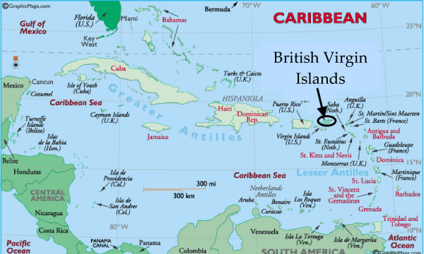
The British Virgin Islands are comprised of some sixty islands that are
located just to the west of Puerto Rico.
These islands are geographically located in the island arc know as the Lesser
Antilles. However, geologically
speaking, the groups of islands are actually located in the Greater Antilles.
There has been much confusion over this in recent
years, but the division between the Greater Antilles and the Lesser Antilles is
located at the Anegada Trough, which is just west of the B.V.I’s. The B.V.I’s, Puerto Rico and the US Virgin
Islands are all located on a small crustal block located on the northeastern
corner of the Caribbean plate. This
piece of crustal plate is bounded by the Puerto Rico
Trench in the north, the Anegada Trough in the southeast, the Muertos Trough to
the south, and Mona Canyon to the west.

Most of the islands in the B.V.I.’s are
volcanic in origin. The movement of the Caribbean plate and the North American plate formed a transform boundary that has led to the formation of the Puerto Rico trench which is approximately 8km in depth and is the deepest part of the Atlantic Ocean. This boundary caused a
chain of volcanoes to form parallel to the Puerto Rican trench. An example of this is the British
Virgin Island’s highest peak, Mount Sage, located on the island of Tortola. Its’ peak is
roughly 1750 ft above sea level. This
volcanic mountain was formed during the Cretaceous age. The results of this transform boundary, which occurred between 120-135 million years ago, created volcanic and sedimentary deposits that form the BVI’s.

Anegada, “the drowned land”, is a group of islands 15 miles
north of Virgin Gorda. Unlike much
of the BVI’s, this island is not volcanic, and was instead formed from coral
and limestone and lies only 28 ft at its highest point. It is home to Horseshoe reef, which is the largest coral reef in the caribbean and the fourth largest reef in the world.