Thursday, May 3, 2012

The future of the British Virgin Islands


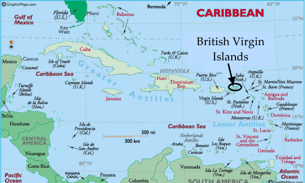
The British Virgin Islands have been around for millions of years and many geological factors have molded these islands into what they are today.  These islands began their lives as volcanoes and eventually evolved into the tropical paradises that they are today.  The single most influential geological factor that has had the most impact on the islands is the Caribbean Sea.  From coastline erosion to weather patterns, this large body of water is manipulating almost every environmental characteristic of the BVI’s.
In ten years, the most significant factors that could potentially change the landscape of the islands would be hurricanes and tropical storms.  Rising ocean temperatures caused by the increased amounts of greenhouse gases in the atmosphere are not only increasing the likelihood of hurricanes in this region, but storm intensity is also escalating.  This boost in storm frequency and intensity will have a great effect on storm runoff and flooding.  These islands are also located along a plate boundary where earthquakes frequently occur.  Any one of these factors could drastically and very quickly alter the landscape of this region.  Hurricanes could kill trees and wildlife, demolish structures and leave the islands completely inhabitable and destroyed.

In the long term, between 100 and 1,000 years from now, anthropogenic factors will be of major concern.  The continued burning of fossil fuels will increase the amount of CO2 in the atmosphere to unprecedented levels.  The atmosphere and the oceans will no longer be able to maintain equilibrium and many adverse conditions could potentially arise.  Higher levels of carbon dioxide in the Caribbean Sea could be detrimental to marine life and to the delicate coral reefs that are prevalent throughout this region.  Anegada’s stunning Horseshoe Reef could be completely destroyed if ocean’s carbon dioxide concentrations meet their 
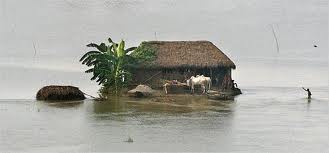
projections.   Sea levels are also expected to rise 4 to 36 inches within the next 100 years.  This increase in Sea level is due to the thermal expansion of ocean water and the melting of glaciers and ice sheets.  This increase in sea level will begin to erode the beaches and flood many of the coastal mangroves found throughout the BVI’s.  In a thousand years, many of the islands could be completely submerged and many others will lose substantial amounts of land.
The future of Horseshoe Reef?

            The future of the BVI’s is uncertain.  Maintaining the delicate balance between Mother Nature and human population will be of the utmost importance.  I hope that many of the grim aforementioned predictions of what the BVI’s will look like years from now will not become a reality.  It is important that we address these climate issues now and make the necessary changes to preserve places like the BVI’s for many years to come.

Thursday, April 12, 2012

Weather and Storm Systems


Wind patterns for the most part remain consistent throughout most of the Caribbean.  Some of these wind patterns are caused by Land/Sea diurnal flows.  During the day, the ocean is at a lower temperature (higher pressure) than the land, which is at a higher temperature (lower pressure). Since air always flows from high pressure to low pressure, winds during the day will blow inland.  This heated air will then rise, cool and descend.  This process will continue during daylight hours and once it becomes night, the process is reversed and winds will flow from land out to sea.


The predominate type of winds found throughout the tropics are called trade winds.  These winds blow from the northeast in the northern hemisphere and from the southeast in the southern hemisphere.  During hurricane season, these winds are the steering force that guide these devastating storms.  These winds can also carry dust from Africa across the Atlantic Ocean and into the Caribbean.

Trade winds also have an effect on the weather patterns of the islands.  The windward sides of the islands tend to receive more moisture through precipitation.  However, the leeward sides tend to be drier. 

The convergence of the northeast trade winds of the northern hemisphere and the southeast trade winds of the southern hemisphere create the Intertropical Convergence Zone.  This area of global air convergence forms a low pressure belt that spans the equator. The air in this zone of low pressure is extremely moisture rich and unstable. This leads to frequent precipitation throughout this region and explains why the tropics have so much annual rainfall.  


Hurricanes and tropical storms are common in the BVI's.  The high sea surface temperatures, the few changes in wind speed, the abundance of water vapor, along with the convergence of trade winds all make for ideal conditions for powerful storms to be produced.

Thursday, March 8, 2012

Weathering, Hydrology, and soil


Sometimes referred to as the eighth wonder of the world, “The Baths” which are located on the island of Virgin Gorda, have some of the most breathtaking views that the BVI’s have to offer.  Located approximately three miles from “The Baths” is Gorda peak. This ancient volcano, which erupted millions of years ago, scattered scores of boulders throughout the southwest corner of Virgin Gorda.  Over millions of years, the ocean’s rising and falling tides along with changes in sea levels, eroded away the softer volcanic rock and left the harder granite boulders that we see today.


The Baths Virgin Gorda 1.jpg 

The weathering of these huge pieces of granite have also created numerous caves and tranquil grottos.

The Baths Virgin Gorda 2.jpg

Gorda-Peak-Virgin-Gorda.jpg
Gorda Peak

The dominant type of soil found throughout the islands is know as Victory soil.  Victory soil is apart of the Inceptisols soil order and contain a mixture of rock fragments (weathered extrusive igneous bedrock) and clay. This soil is not suitable for cultivated crops and is primarily used as rangeland.

victory.gif

The average rainfall throughout the BVI’s is around 27 inches a year but can often vary substantially from year to year.  The total rainfall amounts are amongst the lowest of all the Caribbean nations.  The Limited amounts of rainfall help recharge the aquifers, but only account for a small amount (10%) of the overall sources of fresh water on the island.

hydrograph.gif

Most of the fresh water that is utilized throughout the BVI’s is supplied from desalination plants.  Brackish water provided from shoreline wells and alluvial well fields are treated through the process of reverse osmosis and supply clean drinking water to the 22,000 residents of the islands. 
Baughers-Bay-Desalination-Plant_-Photo-credit_GIS.jpg
Baughers Bay desalination plant located in Tortola


Monday, February 13, 2012

The Birth of the British Virgin Islands

The British Virgin Islands are comprised of some sixty islands that are located just to the west of Puerto Rico.  These islands are geographically located in the island arc know as the Lesser Antilles.  However, geologically speaking, the groups of islands are actually located in the Greater Antilles.


There has been much confusion over this in recent years, but the division between the Greater Antilles and the Lesser Antilles is located at the Anegada Trough, which is just west of the B.V.I’s.  The B.V.I’s, Puerto Rico and the US Virgin Islands are all located on a small crustal block located on the northeastern corner of the Caribbean plate.  This piece of crustal plate is bounded by the Puerto Rico Trench in the north, the Anegada Trough in the southeast, the Muertos Trough to the south, and Mona Canyon to the west.
Most of the islands in the B.V.I.’s are volcanic in origin.  The movement of the Caribbean plate and the North American plate formed a transform boundary that has led to the formation of the Puerto Rico trench which is approximately 8km in depth and is the deepest part of the Atlantic Ocean.  This boundary caused a chain of volcanoes to form parallel to the Puerto Rican trench.  An example of this is the British Virgin Island’s highest peak, Mount Sage, located on the island of Tortola.  Its’ peak is roughly 1750 ft above sea level.  This volcanic mountain was formed during the Cretaceous age.  The results of this transform boundary, which occurred between 120-135 million years ago, created volcanic and sedimentary deposits that form the BVI’s.


Anegada, “the drowned land”, is a group of islands 15 miles north of Virgin Gorda.  Unlike much of the BVI’s, this island is not volcanic, and was instead formed from coral and limestone and lies only 28 ft at its highest point. It is home to Horseshoe reef, which is the largest coral reef in the caribbean and the fourth largest reef in the world.
  

Wednesday, January 25, 2012

Introduction


My name is Garrett Hall and I am a Geography student at the University of Colorado, Denver.  In February of 2009, I traveled to the British Virgin Islands (BVI’s) for a seven-day sailing excursion aboard a 43’ catamaran.  Although most of the trip was spent at sea, we spent time exploring many of the coastal attractions that the BVI’s had to offer.  While I was able to see many of the aspects physically, I want to revisit the amazing landscape from a geographers’ perspective! I am excited to investigate the geographic forms and processes of the landscape.  I hope you enjoy taking this trip with me!